
Kalamazoo ZIP Code Coverage
Nine ZIP codes appear in the official local map and county street-directory material used for Kalamazoo research. The table is a service-area aid, not a legal boundary file. Neighborhood names come from the county’s local context table, and they can appear beside more than one ZIP. Confirm a particular address with USPS and the parcel record before deciding which municipality has the records or which city office is responsible.
| ZIP | Areas Covered in Local Context | Post Office or Station | Postal Note |
|---|---|---|---|
| 49001 | Kalamazoo, including Edison, Milwood, South Side, South Westnedge, Vine, and Westnedge Hill context | Not specified in reviewed official source | Parcel municipality may differ. |
| 49002 | Kalamazoo and Portage, with Pavilion, Schoolcraft, and Milwood context | Not specified in reviewed official source | Crosses postal and municipal context. |
| 49004 | Kalamazoo and Parchment, with Cooper, Kalamazoo Charter, Richland, and Burke Acres context | Not specified in reviewed official source | Cross-boundary service area. |
| 49005 | Kalamazoo PO Boxes Only | Kalamazoo PO-box service | Do not treat it as a street-address ZIP. |
| 49006 | Kalamazoo and Oshtemo context, including Arcadia, Knollwood, WMU/KRPH, West Main Hill, and Westwood | Not specified in reviewed official source | Broad postal-city service area. |
| 49007 | Central business district, Eastside, Edison, Northside, Stuart, Vine, and WMU/KRPH context | Not specified in reviewed official source | Includes Kalamazoo Charter context. |
| 49008 | Colony Farm, Hill ’N Brook, Oakwood, Parkview Hills, South Side, and Westnedge Hill context | Not specified in reviewed official source | Verify the parcel and city boundary. |
| 49009 | Cooper, Oshtemo, Texas, Alamo, Almena, Arcadia, and Colony Farm context | Not specified in reviewed official source | Multiple township context. |
| 49048 | Kalamazoo-area mapping and street-directory references | Not specified in reviewed official source | Confirm current postal and municipal match by address. |
The most important exception is 49005. The county table identifies it as PO Boxes Only, so it is not evidence of a delivery street or a physical location. Likewise, 49002, 49004, 49006, and 49009 show why a Kalamazoo postal name cannot stand in for city or township jurisdiction.
Kalamazoo Postal Address Checks
The USPS postal lookup has three separate routes: by address, by city and state, and by ZIP. Use the address route when the goal is to standardize one delivery address. Use city and state to see recognized postal results, or cities by ZIP to see postal-city information. USPS returns postal information. It does not confirm that a named person or organization is at an address, and it does not settle a parcel’s city or township jurisdiction.
The USPS lookup provides the address, city/state, and ZIP modes used before a Kalamazoo ZIP code directory result is tied to local records.
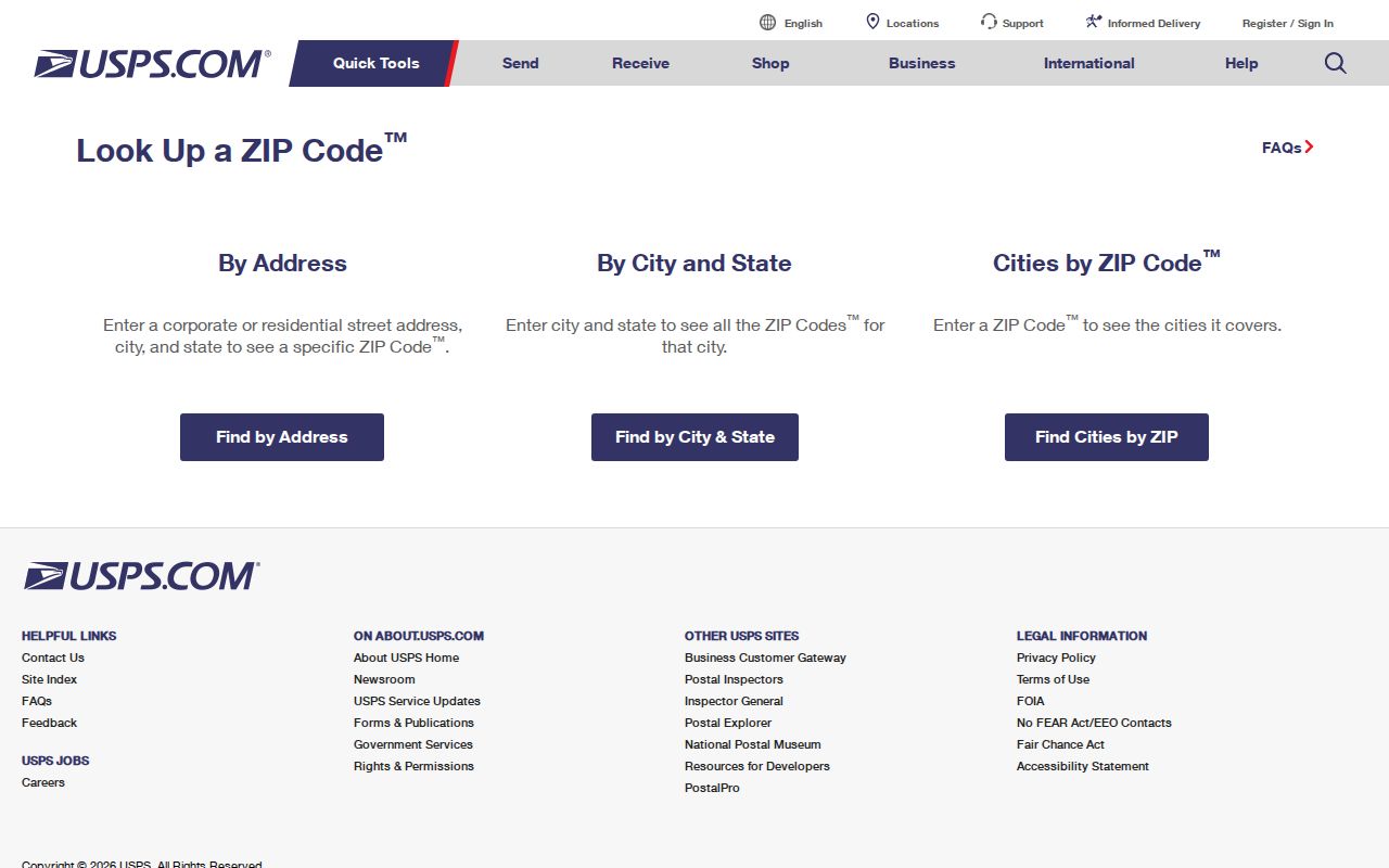
After USPS returns a standardized match, compare it with the county street directory and then the parcel record. That order keeps a postal label in its proper role while giving the property and municipal sources the job of identifying the official local record.
Kalamazoo Postal Lookup Fields
USPS publishes different fields for each lookup mode. The address form uses the delivery address as the main input, while the city and state form offers a broad postal search. City-by-ZIP works in the other direction. These fields are useful for verifying a ZIP before a property, directory, or archive search, especially when an older local source uses a postal city that is not the current municipal label.
| USPS Route | Field | Required | Use for Kalamazoo Research |
|---|---|---|---|
| By Address | Street Address | Yes | Checks the delivery address before an official record search. |
| By Address | Apt/Suite/Other | No | Adds delivery detail when it is part of the address. |
| By Address | City and State | Yes | Supplies postal locality context for the match. |
| By Address | ZIP | No | Can narrow a known address, but does not prove municipal jurisdiction. |
| By City and State | City and State | Yes | Returns postal information associated with a named locality. |
| Cities by ZIP | ZIP | Yes | Checks recognized postal city names for a ZIP. |
A ZIP+4 is a more specific postal delivery code within a five-digit ZIP. It can improve mail addressing, but it is not a parcel number, a city boundary, or a resident identifier.
Kalamazoo Postal Research Workflow
Official local tools do not supply one general ZIP-wide resident list. The county Parcel Search is documented for owner, parcel ID, and street searches, not a ZIP-wide query. City BS&A is address based. Michigan Voter Information Center uses ZIP to narrow a name search, not to return everyone in a ZIP. A useful ZIP code workflow therefore narrows a known address or name instead of treating postal geography as a person list.
- Confirm the delivery ZIP with USPS using the full address, city, and state.
- Open the county Street Name Directory to check the road segment’s range, parity, municipality code, ZIP, and census tract.
- Search the confirmed street or address in County Parcel Search. Retain the parcel ID and compare the municipality shown by the result.
- For a specific person, use Michigan Voter Information Center’s name route with ZIP as a narrowing field when the current interface permits it.
- Use the deed index, city property system, or a dated historical source only after the parcel, address, and record date agree.
A ZIP can reduce uncertainty, but it cannot replace an address-level check. When a postal match points to one road or parcel, continue with the Kalamazoo street directory method for the address and deed trail.
Kalamazoo Street Segment Crosswalk
The Kalamazoo County Street Name Directory provides the most useful official bridge between a postal code and an actual road segment. Its fields include direction, street name and suffix, low and high address range, odd, even, or both-number parity, municipality code, ZIP, 2000 Census tract, and location notes. A road crossing a city, township, or village line may carry different ZIP context along its length.
For an address or road question that the published tools do not settle, Planning/GIS can be reached at 269-384-8112, County Equalization at 269-383-8960, and City GIS at 269-337-8835. New-address proposals go to plngis@kalcounty.com with the municipality, map or shapefile, plat or site information, section, cross streets, and proposed number, street, and ZIP. Library maps and directories offer an alternate historical route when a current segment does not explain an earlier address.
Direction and parity matter in Kalamazoo. The county explains that the even and odd side can change with the north or south baseline and east or west meridian. Meandering roads receive a major direction and keep it. Use those segment details before joining a directory entry, map point, or historic address to a current record. Note: A street name with the right ZIP can still be the wrong segment if its range and parity do not match.
Kalamazoo ZIP Code Boundaries and City Lines
ZIP boundaries are delivery-service geography, while city limits and township boundaries control which local government maintains a parcel record. The official county material places 49002 in Kalamazoo and Portage context, 49004 in Kalamazoo and Parchment context, and 49009 across several township contexts. The county Street Name Directory and parcel record are better tools for an address-level municipality decision than the postal city shown on mail.
Historic work needs an additional caution. Kalamazoo’s citywide renumbering in 1925, the absence of a 1925 directory, older river-based numbering, and documented street-name changes can break a simple address match. Compare 1924 and 1926 directories, then use a plat, Sanborn sheet, and parcel geometry to bridge the old address to the current one.
- Five-digit ZIP
- A postal delivery area used to sort mail. It may cross city or township lines.
- ZIP+4
- An added four digits that identify a smaller delivery segment within a five-digit ZIP.
- PO-box ZIP
- A ZIP used for post-office boxes. It should not be read as a street-address area.
- Unique ZIP
- A postal ZIP assigned for a particular organization or delivery purpose. No Kalamazoo unique ZIP was verified in the reviewed official material.
- Carrier route
- A mail-delivery grouping. It is not a municipal boundary or an official list of people.
Kalamazoo Records After a ZIP Match
Once USPS and the street segment identify a likely address, switch from postal search to the record custodian. County Parcel Search accepts owner, parcel ID, and street modes. City BS&A can show current owner, tax information, land and building facts, sale history, zoning, permits, utility bill information, and invoices for city records. A current owner field is a property-record field, not proof that the owner lives at the address.
County and city GIS add parcel geometry and layers. The city popup can link to BS&A, while county and city maps warn that they are informational and not legal surveys. For historic context, Kalamazoo Public Library has city directories from 1860, street order beginning in 1897, plats, atlases, and Sanborn maps. The library’s historic-house guide recommends checking printed names and street-order sections together with maps and address-number history.
Kalamazoo Postal Privacy Limits
Postal geography should not be used to assemble a list of people. MVIC’s name route uses first name, last name, birth month, birth year, and ZIP as narrowing inputs, but public voter information excludes sensitive fields such as driver or state ID numbers, month and day of birth, phone, email, signatures, and protected-address data. Its address and driver-license route also requires more than a ZIP.
Michigan’s Address Confidentiality Program provides eligible people with a designated address and mail forwarding. A map, ZIP label, voter result, or parcel clue should never be combined to bypass that protection. Official results also change, so record the source and access date and contact the responsible custodian for corrections or certified copies when needed.
Postal limits. A Kalamazoo ZIP code is a delivery aid, not proof of residence, ownership, city jurisdiction, or permission to contact someone.